Quinton Hennigh’s Prescient Vision – The Trend Is Our Friend


The most attractive gold juniors are those with assets in established mining jurisdictions, preferably in close proximity, and on trend, to mines operated by the majors.
One that perfectly fits the profile is Vancouver-based EGR Exploration Ltd. (TSXV:EGR), which is exploring for gold on its monster claim package contiguous, and on trend, to the country’s largest gold operation, Detour Lake, within a region already hosting multiple multi-million-ounce deposits.
Its flagship Detour West property is located approximately 300 km north of Timmins, Ontario.
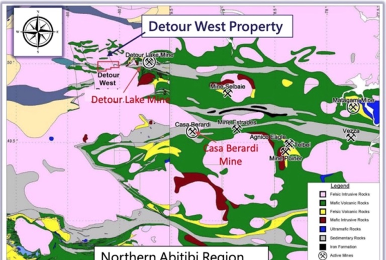
The property covers 40,255 hectares of the Abitibi Greenstone Belt, one of the most prospective regions for gold on the planet. Many gold deposits found in the Abitibi area in the past have been considered world class; the average gold deposit grade is higher than the global average.
The Abitibi region now hosts several key players in the gold mining and exploration space, including Canada’s Kirkland Lake Gold and Agnico Eagle, which merged into one company in 2022, as well as Newmont Mining, the world’s leading gold miner.
The newly consolidated Agnico portfolio includes Detour Lake, which has a mine life of approximately 22 years with expected average gold production of 659,000 ounces per year.
In addition to Detour Lake, Agnico owns the Canadian Malartic mine in northwestern Quebec, which had been the largest open-pit gold operation in Canada prior to 2022. The company is also developing the Macassa and Goldex projects and the LaRonde complex within the Abitibi belt.
Newmont maintains a significant presence in this prolific greenstone belt with three projects: Éléonore, Porcupine and Musselwhite.
The success many have had in the Abitibi is a big reason why many up-and-coming gold explorers continue to gather in the region to this day. Worth noting: there are an estimated 100 million ounces still contained in the ground, so the idea of making new discoveries is quite plausible.
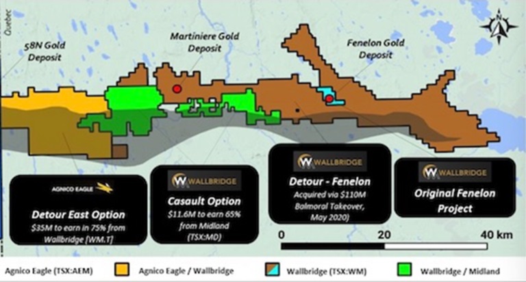
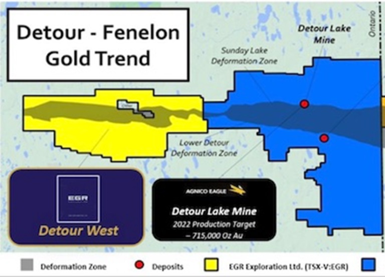
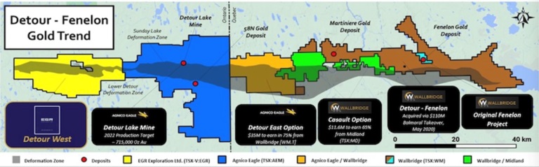
Located in the northern part of the Abitibi, the Detour-Fenelon Gold Trend spans over 200 km of prospective strike length potential along the Sunday Lake and Lower Detour deformation zones. EGR’s property is located 20 km west of the Detour Lake open-pit (hence the name “Detour West”), and also directly adjoins Agnico Eagle’s holdings along the trend. The eastern portion of the trend is being explored by Wallbridge Mining in Quebec. The trend continues to deliver new gold ounces with the recent Chebistuan discovery east of Fenelon and resource expansion at Detour Lake, Fenelon and Martiniere.
In July 2020, EGR — under its previous name Gambier Gold — entered the Detour West project after signing an option agreement on the property, which at the time was less than half the current size.
To maximize its chance of success, EGR has since increased its landholding and consolidated the entire 40,255-hectare Detour West project area, which is now 35 km long by 15 km wide.
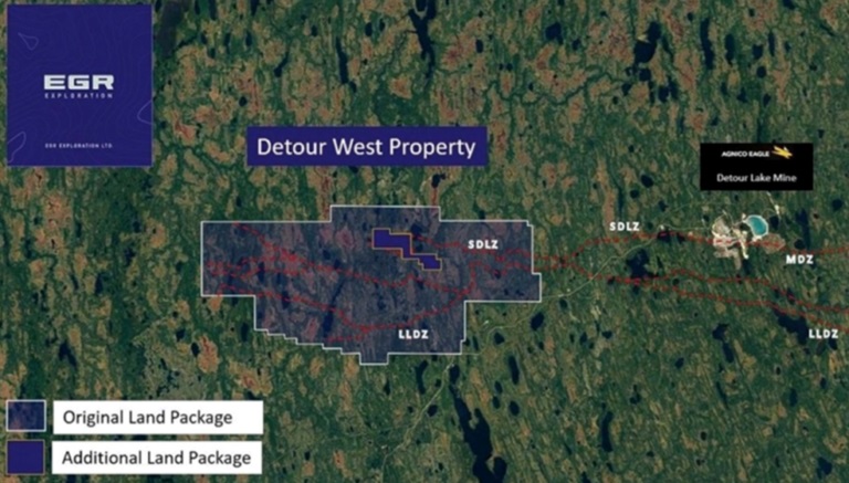
It then carried out an airborne magnetic survey covering approximately two-thirds of the property to investigate the extensions of various deformation zones known to be associated with gold mineralization along the Detour-Fenelon trend.
Geology
Gold mineralization is associated with the structural contact between mafic and ultramafic volcanic rocks of the Deloro Assemblage and younger Caopatina Assemblage sediments. This structural contact is a regional-scale thrust zone, the Sunday Lake Deformation Zone (SLDZ).
A key task for EGR, as it goes about exploring Detour West, is testing the extension of the SLDZ, trying to prove that Detour West is on trend with Agnico-Eagle’s Detour Lake mine and its 20.7Moz of reserves.
“We see the east-west structures on our property, we know that the Sunday Lake and the Lower Detour and the Detour-Fenelon trend is an E-W structure and that’s where people are having success and gold can be hosted in a variety of different types of rocks, so we have the potential to make a discovery,” said CEO Daniel Rodriguez in a recent interview with Ahead of the Herd.
A regional geology map from Agnico Eagle shows three deformation zones running east-west, right to the edge of Agnico’s Detour Lake property. The deformation zones are labeled Sunday Lake, Massicote and Lower Detour. Notice the Sunday Lake Deformation Zone runs through the Detour Lake mine’s Main Pit, West Pit, and the West Pit Extension.
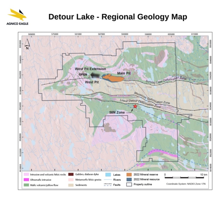
About a year ago, Agnico-Eagle was conducting exploration 12 kilometers away from EGR’s Detour West, drilling out the West Pit in an effort to go underground to add resources. The pit itself is 25 kilometers away from Detour West.
This below image reflects an important change to Agnico Eagle’s interpretation of the geological structures crossing its Detour Lake property.
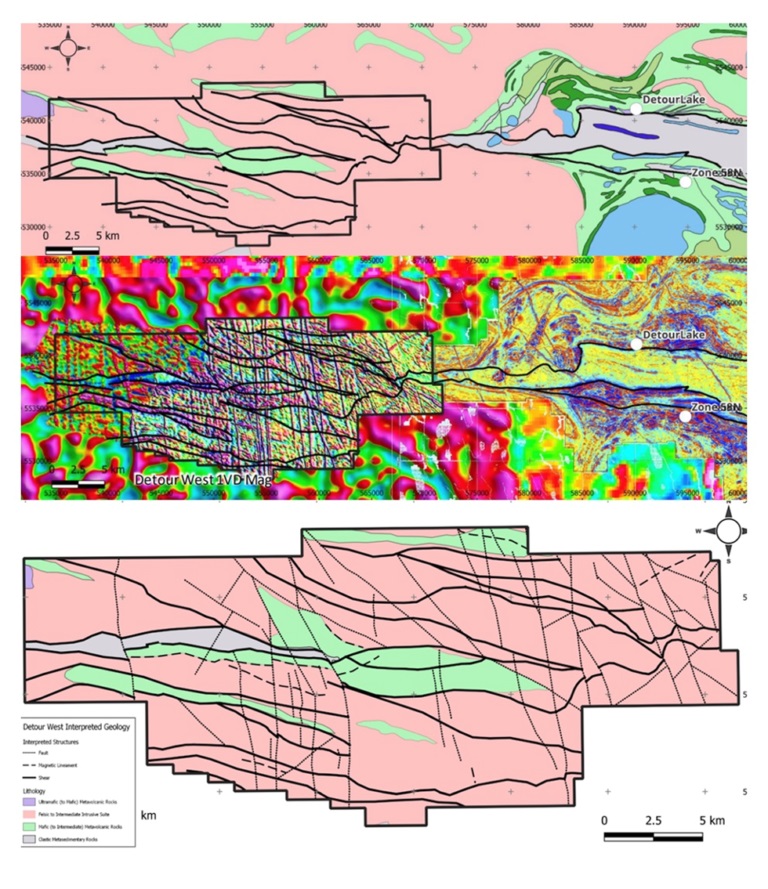
If the Detour Lake – Regional Geology Map is correct in its interpretation, it would mean that, rather than ending abruptly at the western edge of the Detour Lake property, the Sunday Lake Deformation Zone, and potentially the other two deformation zones, Massicote and Lower Detour, continue in a westerly direction, possibly right onto EGR’s Detour West.
As we ponder that thought, let’s back up a few million years.
About 70% of the world’s gold is contained in orogenic lode deposits, similar to what EGR has in its Detour West project. These deposits begin their journey deep down in the Earth’s mantle. It’s a familiar geological narrative. Where continental plates collide, heat and pressure causes water trapped in the minerals to be released. The boiling-hot water makes its way up through the crust in cracks and fissures. As it does so, it carries metals up towards the surface, including gold and arsenic. As the water moves from deep to shallow environments, chemical changes cause the gold to precipitate out, forming lode deposits.
These lode deposits can occur over a huge vertical profile, up to 20 kilometers deep. In the Mesazonal (mid-zone) environment of the Canadian Shield, gold deposits are hosted by structures that occurred at a reasonably deep level, from 5-10 kilometers down in the crust. They tend to deliver big gold systems and the grades once you get into a system tend to be reasonably predictable.
The red box on the map below shows EGR’s Detour West property; it’s just west of the Detour Lake open pit, which used to be operated by Kirkland Lake Gold but is now merged with Agnico Eagle. While the property looks small on the map, it’s actually large — 35 km long by 15 km wide. As explained above, there are three deformation zones running east-west, right to the edge of Agnico’s Detour Lake property, possibly extending onto EGR’s Detour West.
Taking a closer look at the map below, notice the shaded-gray east-west trending feature, that is the zone — actually a collection of zones — of faulting and mineral deposition. The red dots are gold deposits.
What makes EGR’s ground depicted in yellow so intriguing?
According to respected geologist Quinton Hennigh, it’s when deformation belts like the Sunday Lake Deformation Zone become constricted, or “squeezed”. The map shows a narrowing of the gray, snake-shaped band at the east end, and a similar narrowing at the west end.
“One of the things I like to see is where you get into these deformational belts you see them become constricted or compacted,” Hennigh said in a 2021 video presentation. “There’s a lot of granites that were coming up out of the ground at the time of this deformation and they start to squeeze the rocks around them called greenstones and when they do that you can get higher grades.”
“As you go westward, Detour Lake is where the structural zone is wider and in those areas you can still form gold deposits, but they tend to be bigger, low-grade deposits and that’s exactly what Detour is, but guess what? As we go further west over onto [EGR]’s ground, notice that deformational zone starts to grow skinnier and skinnier, tighter and tighter. What that tells me is that there’s good potential for high-grade discovery in that region.”
Like any good geologist, Hennigh has facts to prove his theory. The slide below shows a geologic map of the western end of the deformation zone. Notice there is a lot of detail drawn on the right, surrounding the Detour Lake mine. That’s because a lot of exploration has occurred there. To the left there is much less detail, as indicated by the red question marks and a few green blobs. Why is this area devoid of geologic information? Because it’s covered with glacial till. During the last ice age, glaciers scoured the Canadian Shield and dug into the surface, breaking free small rock particles that included quartz veins. The gold became concentrated in the basal (base) till, forming deposits that can sometimes be buried under 10, 20, 30 meters of glacial till overburden.
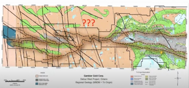
Importantly, the fact that Detour West is covered in a thick layer of glacial sediment, explains why it has never been explored before.
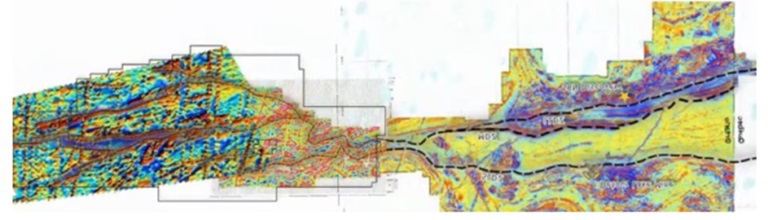
The magnetics survey’s below are interpreted to show that the structures start in the east, continue west to Detour Lake, and onto ground held by EGR.
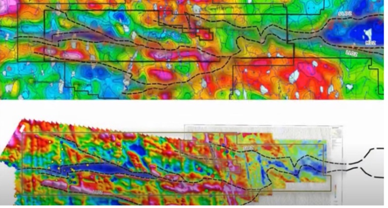
“You can see a number of very discreet, very crisp structural corridors through that area, those are the kind of things that host gold deposits,” said Hennigh.
Further evidence of connectivity is shown in the image below.
“You can see right away that the magnetics over at Detour Lake, as they progress those major structural zones that are deep-rooted and brought up those fluids, they carry straight over, they kind of get squeezy in the middle and then they start blowing out into a series of horsetail structures as you go westward,” Hennigh said. “I love that environment, that means you’ve got multiple structural breaks all tapping probably a deeper structure that goes way down in the ground, and those are the kind of things that allow a lot of gold-bearing fluids up in many cases. So this is good hunting ground.”
Analogs
While the Detour West property is unique, it certainly isn’t without comparisons. The map below shows an overlay of the Destor-Porcupine Fault Zone, located further south.
This is a large goldfield associated with a big deformation zone. On the left, notice the Timmins gold camp. Moving east, you see the Kirkland Lake gold mine and then, crossing into Quebec, the Rouyn-Noranda and Val d’Or mines. The area hosts well over 200 million ounces. According to Hennigh, “size-wise the deformation belt which is called the Sunday Lake and Detour Lake deformation zone, up in this country, is comparable in scale to that of the well-known, well-established Destor-Porcupine Zone.”
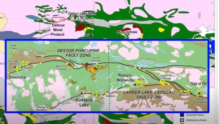
Onyx Gold’s Golden Mile project is analogous to Detour West because both are under glacial till. It also happens to be on trend with the Timmins camp seen on the map above.
The 94-square-kilometer property is located 9 km northeast of Newmont-Goldcorp’s multi-million-ounce Hoyle Pond deposit in the Timmins gold camp of northeastern Ontario.
It is situated on a major flexure (bend) of the Pipestone Fault System, where it crosses the “Porcupine Giant Mine Corridor” that has produced more than 55 million ounces of gold.
Neighboring gold deposits on the north sediment contact/Pipestone Fault include Fenn-Gib (3.4Moz), Clavos (+300Koz – 6 km to the east), Bradshaw (+1Moz) and Lake Shore’s (Tahoe) Timmins West deposit (+1.9 Moz).
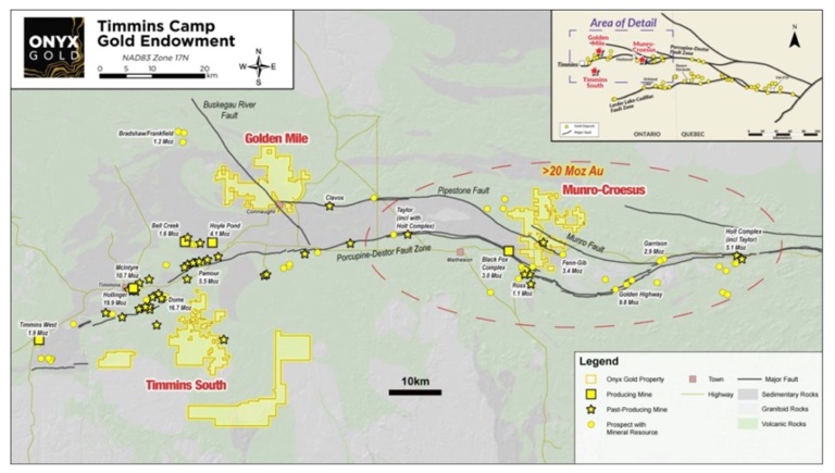
Timmins camp gold endowment and Onyx properties
A five-hole (1,182 meter) drill program was completed in 2014; two holes intersected a graphitic shear zone at the deformed unconformity between carbonate altered komatiites and Porcupine sediments (Timmins West mine setting) along the interpreted Pipestone Fault.
A four-hole (1,179 meter) drill program in 2020 successfully intersected the Pipestone Fault, yielding anomalous gold values, associated gold pathfinder geochemistry and veining in permissive rock units known to be important hosts for gold mineralization within the Timmins camp. The known strike length of the Pipestone Fault on the project has now increased from 600 meters to over 2,000 meters.
Airborne magnetic/electromagnetic surveys have identified prominent structural breaks and multiple areas for drill targeting.
An 85-kilometer overwater seismic survey was completed in 2022 on Frederickhouse Lake to map the depth of the sediment and bedrock to aid drill planning and interpretation of bedrock geology and structures. Frederickhouse Lake is a large, shallow (2-4 meters deep on average) man-made lake covering the interpreted structural intersection of the Pipestone Fault and the Porcupine Giant Mine Corridor.
On-trend properties
Now let’s take a look at some of the other properties on-trend with Detour West.
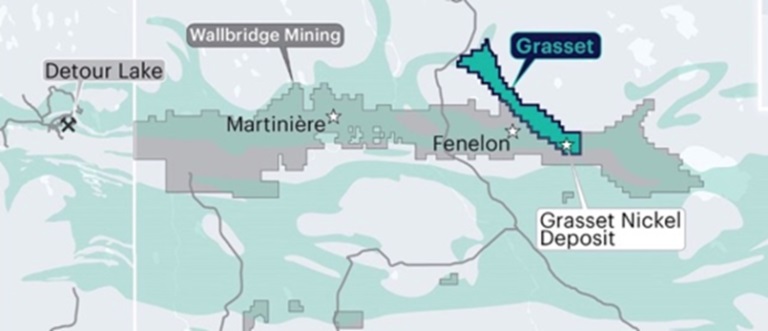
Grasset nickel project
Archer Exploration’s Grasset nickel-copper-cobalt-platinum group elements (PGM) project, located on the eastern end of the Detour-Fenelon Gold Trend, has an indicated resource of 5.5 million tonnes grading 1.53% nickel-equivalent.
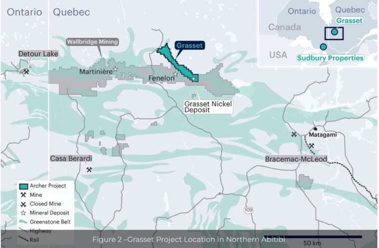
Archer acquired the project from Wallbridge Mining in July 2022. According to Archer, the Grasset deposit is one of the largest nickel sulfide deposits in Canada’s Abitibi region, and the only North American nickel sulfide deposit with >50,000 contained tonnes of nickel and an average nickel grade of over 1.5% that is not controlled by a major mining company.
The deposit comprises two sub-parallel, sub-vertically dipping zones (H1 and H3 horizons) of disseminated to locally semi-massive sulfides mineralization. The H1 and H3 horizons each remain open at depth and along strike to the northwest.
The vast majority of the Grasset Ultramafic Complex is underexplored, and limited exploration prior to 2016 resulted in the discovery of several significant nickel sulfide showings along the entire 23-kilometer-long belt.
Most notable is the GUC Central discovery, 7 kilometres northwest of the Grasset deposit, which hosts a 950-meter-thick ultramafic sequence, with several mineralized horizons of nickel sulfides and a best mineralized intercept of 4.14% Ni over 0.65 meters, within 7.58m of 1.05% Ni.
Archer recently started its 2024 winter exploration program at Grasset involving three to four diamond drill holes and up to 2,000m of drilling.
The first drill hole will test the newly identified N9 electromagnetic conductor, about 2 kilometers to the northeast. Downhole surveys on two other holes will be conducted, providing a higher resolution of the underground conductive anomalies and refining current exploration targets.
Last year, three holes defined a high-grade extension of the H1 Horizon, up to a depth of 450 meters below surface. The drill program will further explore the high-grade H1 Discovery Zone.

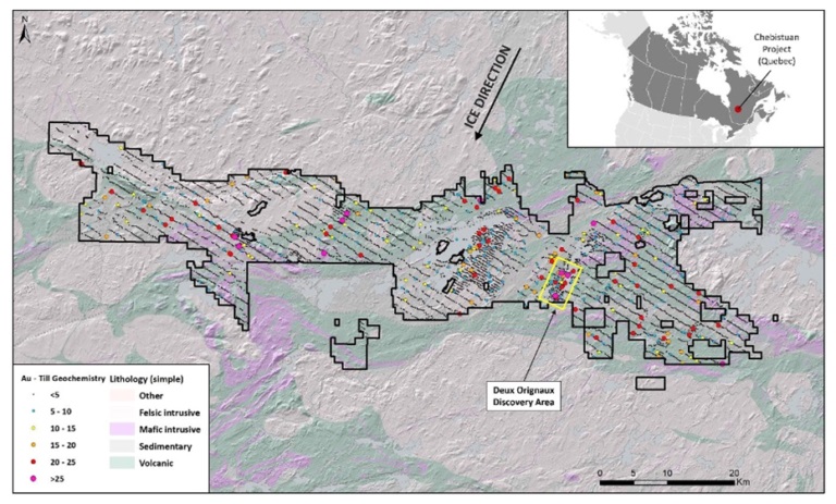
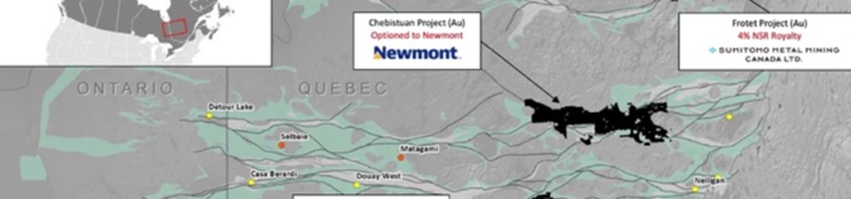
Chebistuan gold project
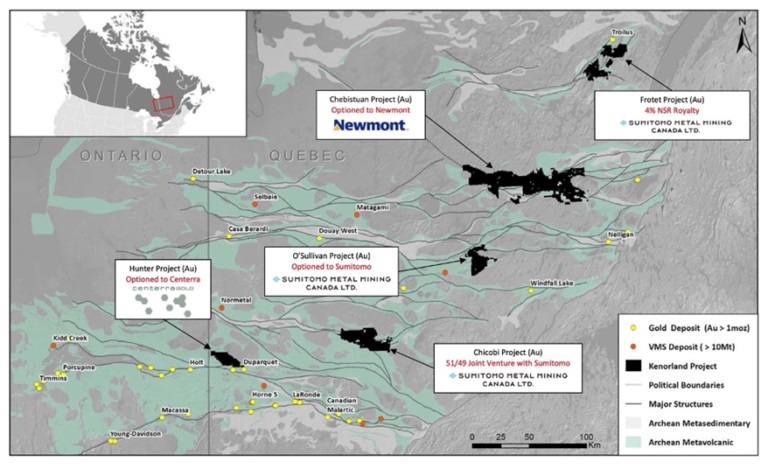
Kenorland Minerals’ Chebistuan gold project is located east of Detour West in the province of Quebec. Chief geoscientist Dave Stevenson is an EGR director.
The property covers approximately 100 kilometers of a major east-west trending deformation zone. Like EGR, Kenorland is trying to determine whether Chebistuan may be an extension of the Sunday Lake Deformation Zone.
Chebistuan and Detour West also have glacial till in common.
The project is under joint venture with Newmont Mining, which can earn a 51% stake within three years if it completes certain exploration expenditures and cash payments to Kenorland.
The Chibougamau and Chapais mining camps, which have produced over 6.5Moz of gold and 1.6 billion pounds of copper historically, are located directly to the east of the Chebistuan property.
Kenorland recently announced the grassroots discovery of an intrusion-related gold system at Chebistuan.
Last June, the company reported the results of 2,170 meters of drilling in seven drill holes. Seven shallow holes up to 358m long were drilled along two fences to test across a structural and magnetic corridor within the Deux Orignaux target area. Along the eastern drill fence, hole 23DODD005 intersected a mineralized porphyritic syenite intrusion over 157.20m averaging 0.41 g/t Au from 84.41m to 241.61m downhole, including 20.61m at 0.97 g/t Au, with individual samples returning up to 7.14 g/t Au over 0.31m along the northern contact zone.
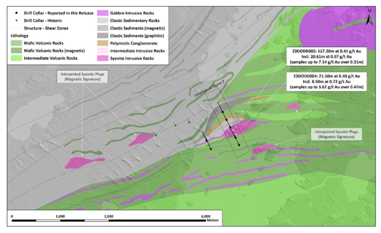 Plan map of Deux Orignaux drilling (currently reported assays)
Alkaline, intrusive-hosted disseminated sulfide gold systems represent a significant deposit type across the Abitibi Greenstone Belt including the Young-Davidson deposit along the Larder Lake-Cadillac fault zone, and the Duparquet deposit along the Destor-Porcupine fault zone. Many of these systems have potential for higher-grade mineralization such as the Lac Bachelor-Moroy deposit, located approximately 75 km to the southwest of the Deux Orignaux discovery.
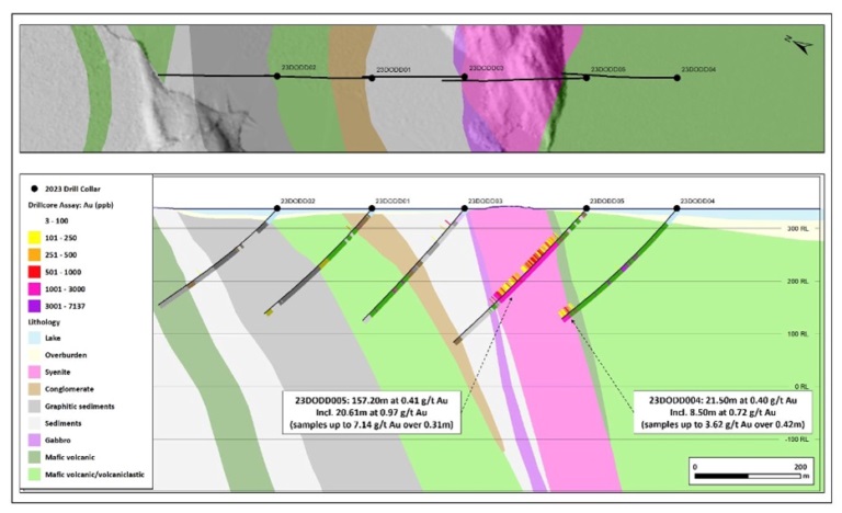
Cross section of Deux Orignaux drilling (geology and currently reported assays, looking east)
The Deux Orignaux target area was identified during property-wide systematic geochemical sampling in 2020, with subsequent infill sampling leading to an area of anomalous gold geochemistry and gold grains in glacial overburden.
 Chebistuan project geology and gold-in-till geochemistry
Grasset Gold project
Wallbridge Mining’s Grasset Gold project is part of Wallbridge’s 830 square-kilometer Detour-Fenelon Gold Trend land package. It is located adjacent to the Fenelon Gold property 100% owned by Wallbridge, and Archer Exploration’s Grasset nickel project, of which Wallbridge owns 19.9%. Agnico Eagle has a joint venture with Wallbridge on Detour East.
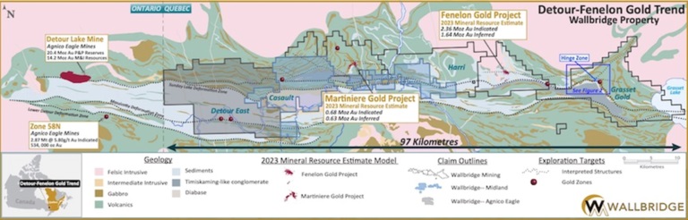 Wallbridge’s Detour-Fenelon Gold Trend land package.
The Grasset Gold project is on the far right
The Grasset Gold project covers about 20 kilometers of the Sunday Lake Deformation Zone (SLDZ), and to the east covers a portion of the Lower Detour Deformation Zone (LDDZ).
Gold mineralization was intersected both within the regional-scale SLDZ, which transects the project, and within secondary structures marginal to the Grasset Ultramafic Complex. Significant discoveries include the Grasset Gold Zone with an intercept of 1.6 g/t Au over 33.0m, including 6.15 g/t Au over 4.04m.
In recent news, Wallbridge reported final assay results of the inaugural 2023 drill program which expanded the known gold mineralization discovered in the first holes reported on Nov. 13, 2023.
The program was designed to define the geological framework of the Grasset East Flexure target area.
The program focused on the intersection of a large fold structure with a flexure (bend) in the SLDZ, the main structure controlling gold mineralization along the Detour-Fenelon Gold Trend. It was also designed to test structures interpreted from recently collected high-resolution airborne magnetic data.
The program identified multiple grassroots gold occurrences under glacial overburden cover. Drilling along the northern contact of the SLDZ intersected gold mineralization in 12 of 20 holes over a 5-kilometer strike length (Hinge Zone and Targets G5 & G11) in a similar geologic setting to Agnico Eagle’s Detour Lake mine.
New assays received from the 2023 drill program expanded upon the gold mineralization previously reported within the Hinge Zone (targets G1 & G2) with intervals including 12.11 g/t Au over 0.50 meter and 4.99 g/t Au over 1.20 meters.
“Grasset Gold covers approximately 20 kilometers of strike length with favorable geology along the northern contact of the SLDZ, a similar setting to the Company’s Fenelon and Martiniere Gold deposits and Agnico Eagle’s Detour Lake mine,” said Attila Péntek, Wallbridge’s vice president, exploration.
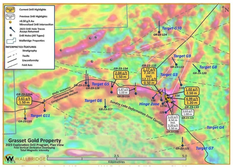 Grasset Gold property, 2023 exploration drill program, plan view
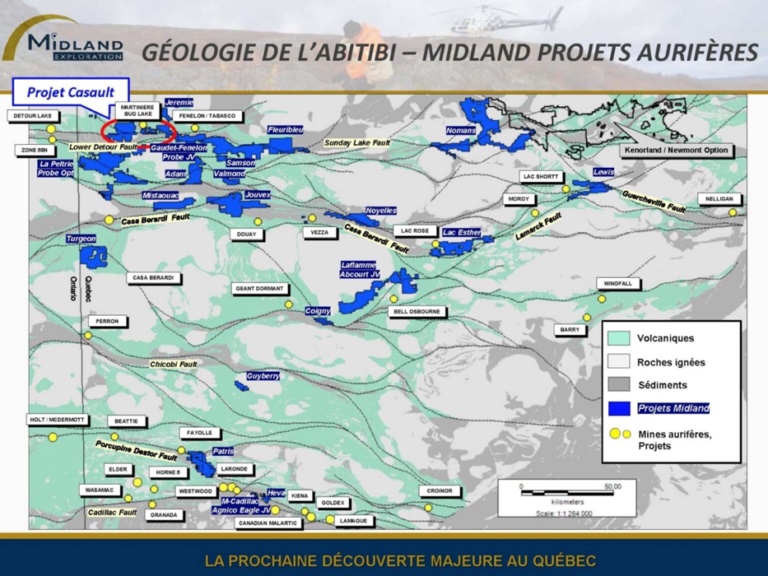
Probe Gold and Midland Exploration also have properties within the Sunday Lake Deformation Zone, with Probe announcing a 7,500-meter drill program last July on its Detour Quebec project, as well as the Midland La Peltrie option property.
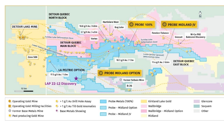
The program continued testing the large mineralized copper-gold-silver-molybdenum system discovered in 2022, which remains open along strike and at depth.
The drilling also focused on two new gold targets along the Lower Detour Deformation Zone, as well as follow-up drilling on one gold target along strike of Agnico Eagle’s 58N high-grade gold discovery, which is approximately 10 km to the west.
In January Probe announced that 2023 drilling at La Peltrie was successful in demonstrating both continuity of the Cu-Au-Ag-Mo system, and the presence of higher-grade mineralization.
In 2014, Midland signed a letter of intent with SOQUEM to acquire a 50% undivided interest in its Casault and Jouvex gold properties, then wholly owned by Midland, and to create a joint venture once the option has been exercised.
SOQUEM, a subsidiary of Investissement Québec, has a mission to promote the exploration, discovery and development of the province’s mineral resources.
The Casault property covers the Sunday Lake Fault over more than 20 kilometers of strike length, and is located about 40 km east of the Detour Lake gold deposit, which currently hosts 15.8 million ounces of gold in near-surface proven and probable mineral reserves.
A recap – The trend is your friend
In gold exploration the trend truly can be your friend. Have a second look at the below map, the first thing you’ll have noticed is the east/ west string of gold mines strung out along the Sunday Lake Deformation Zone (SLDZ).
After reading this article you know there are a lot of companies still working along this east/west trending deformation zone. And still making discoveries. You can also see there have been more than a few gold mines built along the SLDZ from previous discoveries.
It has always been thought the SLDZ, and the other zones like the Lower Detour, had known eastern/ western limits. It wasn’t that the western end was tested, no one bothered, it was under glacial till.
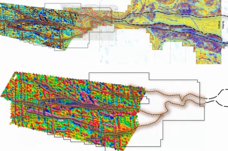
The magnetics survey below are interpreted to show that the structures continue west to Detour Lake, and onto ground held by EGR.
“You can see right away that the magnetics over at Detour Lake, as they progress those major structural zones that are deep-rooted and brought up those fluids, they carry straight over, they kind of get squeezy in the middle and then they start blowing out into a series of horsetail structures as you go westward,” Hennigh said. “I love that environment, that means you’ve got multiple structural breaks all tapping probably a deeper structure that goes way down in the ground, and those are the kind of things that allow a lot of gold-bearing fluids up in many cases. So this is good hunting ground.”

Is Quinton Hennigh’s interpretation, a potential prescience vision, that EGR’s CEO Daniel Rodriquez and CFO Mark Brown bought into correct?
Is this where the trend becomes our friend?
Exploration
EGR’s exploration plan is clear and simple: replicate the same methods that have been successful for Agnico Eagle at the Detour Lake mine. As mentioned, the company wants to test the extension of the Sunday Lake Deformation Zone, trying to prove that Detour West is on trend with Agnico Eagle’s Detour Lake mine and its 20.7Moz of reserves.
An airborne magnetic survey has been flown on the property, located 20 km west of the Detour Lake pit. That survey, plus historical data, a Lidar interpretation, and limited outcrop prospecting, indicate there are possible gold-bearing structures running onto Detour West.
The next step is to drill it.
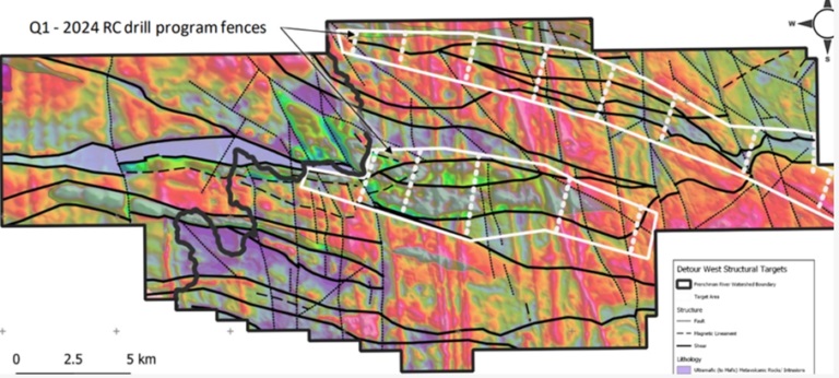
The mag survey findings will guide the implementation of a comprehensive till and top-of-bedrock reverse circulation drill program, which EGR expects to start this quarter.
The drill sites are currently being permitted, including consultation with local First Nations, and in late December a crew was on site examining the stream crossings by snowmobile.
The drill program envisions a regional approach to investigating prospective structural environments across the sprawling 40,000-ha property. To do that, 85 reverse-circulation (RC) holes will be sited on fences spaced roughly 3 km apart, with the holes on each fence spaced every 400m.
“That will give us a giant picture of the property and then be able to narrow down our targets further,” said Rodriguez. “We’ve created our plan for drilling, and we have fences running across two of the major structures that we see.”
Rodriguez said the idea is to test several targets and not just home in on one or two because it’s possible a discovery could be missed that way.
“I’d rather scratch a majority of the area to know where we need to, or not, scratch later,” he said, adding “I want to make sure that we’re covering this whole thing.”
Once EGR can show enough gold-in-till from the fenced RC holes it can vector into the source of the mineralization.
“I see the potential of this Detour West project as being very, very interesting,” said geologist Quintin Hennigh. “It’s very early stage, there’s no question, but it is the kind of play that I see can catalyze a company and generate huge returns if they make a discovery.”
EGR has everything AOTH likes to see in a greenfield exploration project; it checks all my boxes: it’s got power, roads and even cell phone service. It’s located in a geopolitically safe jurisdiction, in one of the most famous gold belts in the world, the Abitibi. Most importantly, it’s possibly on trend with Detour Lake’s 20-million-ounce deposit.
EGR’s current geological theory is that the Detour-Fenelon Gold Trend continues onto Detour West, and the anticipated 2024 drill program intends to prove (or disprove) whether Detour West is on trend with Detour Lake.
EGR Exploration Ltd.
TSXV:EGR
Cdn$0.04, 2024.02.05
Shares Outstanding 40.2m
Market cap Cdn$1.6m
EGR website
Richard (Rick) Mills
aheadoftheherd.com
subscribe to my free newsletter
**********